“This prototype has provided a very viable proof of concept of a smart interactive map, fulfilling the brief of answering the “Where am I?” question on a physical map.”
David & Ala, UKESF Scholars and University of Southampton students
Electronics is all about using technology to solve problems and make people’s lives better. At the UKESF, we like to publicise innovative projects undertaken by undergraduates at our partner universities. One project that recently caught our eye was an ‘Interactive Smart Textiles Map’. This was a project undertaken by a group of MEng students, including two UKESF Scholars, from the University of Southampton. We asked David and Ala, to share their thoughts about the project. This is what they told us:
SplashMaps Ltd, who produce flexible fabric maps, sponsored the project. They requested that Electronics be integrated into their product, to display the user’s location on the map, whilst still maintaining the map’s original flexibility and feel.
The project was a continuation from a previous year; therefore, it was important to build on the previous team’s findings and make improvements. It was clear from the outset that the parts of the systems we wanted to focus on were the LEDs, GPS size and product integration as well as adding an off-the-map feature and additional multipurpose LED grid for a refined informational display. It was decided to split the team into three main area of focus:
- The display team would use LEDs to display the user’s position on the map with any additional information
- The navigation team would work on the GPS circuitry along with an electronic compass
- The power team would develop a wireless power system between a portable transmitter and flexible receiver circuit housed in the map
The original design plan for the integrated map is seen below:
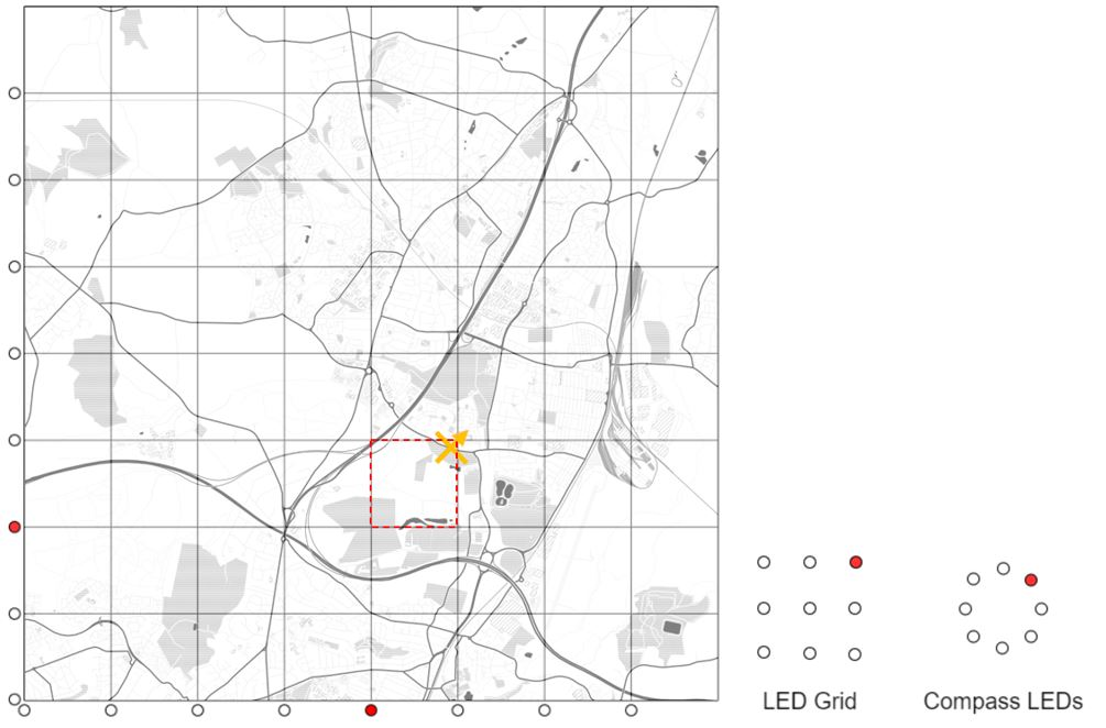
Figure 1: Initial integrated map design.
We only had 12 weeks to complete the prototype, therefore planning was key. The first 4 weeks were spent on researching potential ideas and the creation of a detailed specification and plan by each sub-team, weeks 4-8 on designing the system, schematics, PCBs and making the individual systems, and weeks 9-10 spent on whole system integration and putting the product together. Finally, weeks 11-12 involved summarising and presenting our findings in the form of a report and poster.
The prototype produced in this project contains a large number of features that went a long way to differentiating the integrated map from conventional products. We devised a solution to indicate in which of the map’s grid squares the user is located, and we also refined the location, within each 1km square with an additional 3×3 LED grid. Adding an electronic compass helped with direction.
We ensured that the Electronics we incorporated did not compromise the map’s water resistance. One extra feature we included was an ‘off-the-map’ function, so even when outside of the mapped area, the navigator is shown where they are in relation to the mapped area in order to find their way back to help re-orientate themselves.
To see the map in action, watch the demonstration video on our YouTube channel:
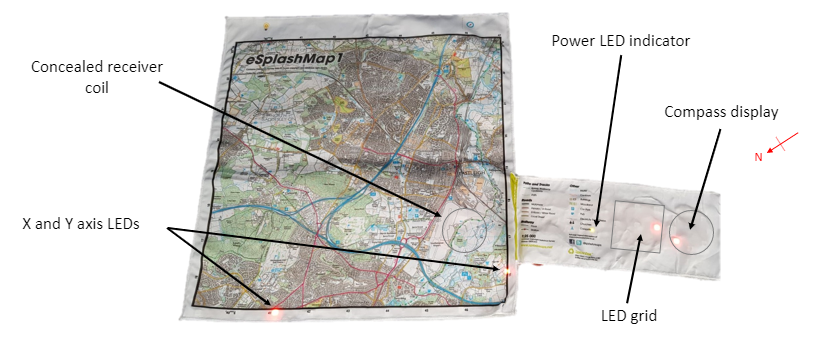
Figure 2: Final Integrated map prototype produced.
This prototype has provided a very viable proof of concept of a smart interactive map, fulfilling the brief of answering the “Where am I?” question on a physical map. We know that there are no guarantees that this solution will be developed into a final market product. Nevertheless, it does show great promise and has a number of potential development routes.
The project has been a tremendous success and it has been well received by the partner company SplashMaps, with Managing Director David Overton stating: “We’re delighted to have, in our hands, a working version of a long-held vision thanks to the students’ work. We’re proud to represent this work at the Wearable Technology Show as a significant step on the way to a fully dynamic and interactive fabric map.” It is certainly a novel and intriguing concept, and we are eager to see where it will progress.